 |
| Phyllis, myself, and Kiele Nelson near the start of our hike. |
 |
| Small waterfall on the way up Aspen Grove Trail. |
 |
| Our destination Timpanogos Peak in the far background. |
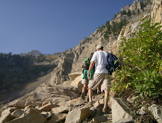 |
| Working our way through some rocks. |
 |
Myself, Phyllis, Kiele and Kevin--old people pretending they are young.
Give us credit we're out doing something! |
 |
| The summit saddle.Timpanogos Peak in background. |
 |
| The end of the trail about 11,500 feet or so. |
 |
| Starting back down the Timpooneke side. |
 |
| Looking back toward Timpanogos Peak on the way down. |
 |
| We dropped off several high meadow plateaus on the long hike out. |
My fear of heights kicked in hard at the saddle summit near the peak of Timpanogos. I stared at the slick looking rock with a slight tilt and could not make my feet step on it. A hiker that we had periodically shared the trail with walked back to me and offered her hand to help me through this scary situation. I took her hand walked across the scary area and onto the saddle that looked out over Utah Valley. Smoke from forest fires in Idaho had blown into the area on the north wind so the view was a bit hazy. Still we could see Utah Lake, the cities of Provo and Orem, and other smaller cities.
I knew I was not going to the peak. My mind was made up. My wife was disappointed to come this far and then not reach the summit. I felt bad for her. We discussed several options that would enable her to reach the peak but in the end it was not to be. She hiked to the corner where the trail started a series of climbs to the peak and had her picture taken by some friendly hikers from Florida. I felt good for making it to the summit saddle. It was a long hike uphill for the most part. The views along the trail were majestic and beautiful. I was satisfied. The thought of being within a mile of the actual peak and not going to the top will probably haunt my wife for a long time.
We hiked with some friends who were very strong hikers. I felt bad for dragging them down. It was nice to hike and talk with them. The plan was to leave a car at the Timpooneke traihead drive to the Aspen Grove trailhead, hike up the Aspen Grove trail and then back down the Timpooneke trail to the shuttle car and then drive back to the Aspen grove trailhead. This would mean we would be hiking approximately 14 or 15 miles. We would attain an elevation of around 11,000 feet.
Utah had one of the driest years on record in 2012. The lack of snow and precipitation made an impact on the size of snowfields in the drainage. The usual springs and waterfalls were almost all dry by the end of September. Still the scenery was fabulous with the fall colors starting to abound.
This hike had a little of everything--elevation gain, rocks, boulders, quakies, pines, a few late season wildflowers, a herd of mountain goats, and distant vistas. It was well worth the effort and as Gregg Witt writes in his book,
60 Hikes within 60 Miles of Salt Lake City: "Some hikers make their ultimate destination one of the many waterfalls, meadows, or lakes, while others go as far as the saddle, less than a mile from the summit, and consider the view from the saddle as a worthy reward for their effort."


